A major winter storm could affect the eastern United States

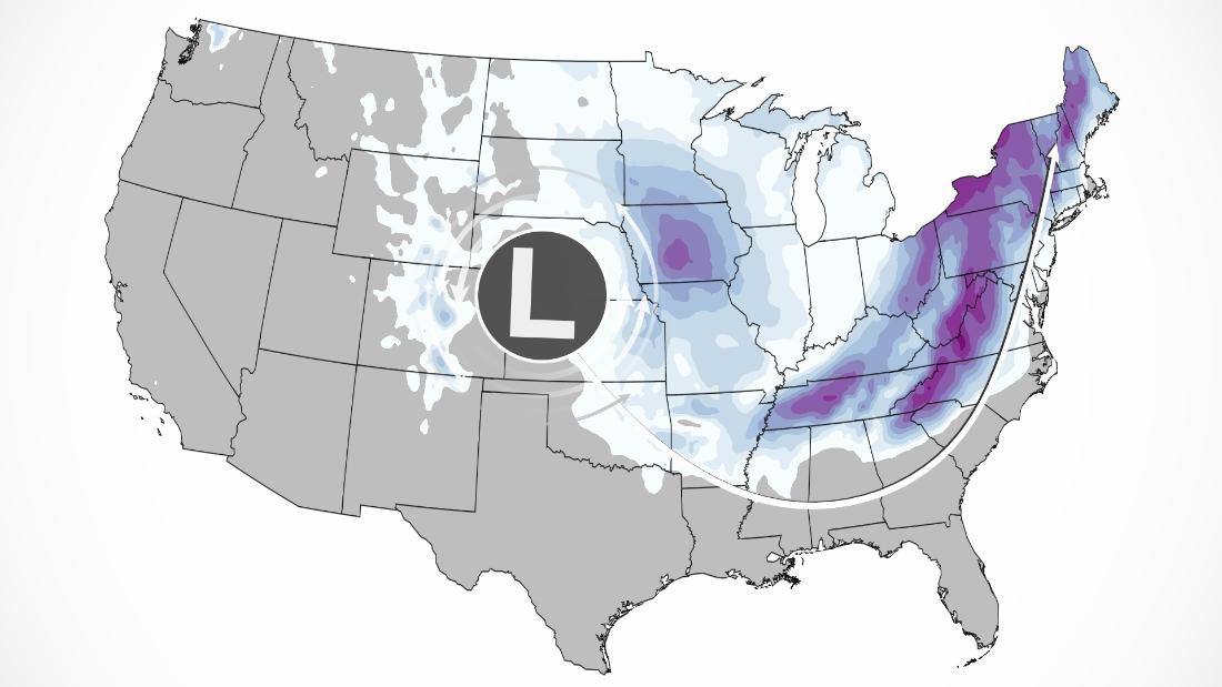
(CNN) – More than 50 million people are on alert because of a dangerous system that is making its way from the central United States to the south and then to the northeast in the next three days.
The low pressure system currently in the Central Plains region will begin entering the lower Mississippi Valley region Friday night. On Saturday, that depression will slowly meander across the southeast before turning north along the east coast.
Rain, snow, sleet – how about all of that in 24 hours? This will be the case for some states this weekend.
So, let’s break down the potential dangers in each area.
Snow forecast: Check these maps to see how much snow is expected in your area.
Upper Midwest to Central Mississippi Valley
The storm will move through parts of the Midwest and the central Mississippi Valley today, up to a foot of snow.
The winds will also rise in these areas, which will lead to snowfall and poor visibility.
“Travel impacts are expected to be significant at times, especially during afternoon school outings and overnight travel,” the National Weather Service (NWS) said. in Des Moines.
Heavy snow will fall in parts of Dakota, Iowa and Minnesota with 6 to 12 inches of snow expected.
From there, the system will drop further south, heading to Missouri, Arkansas, and Kansas.
“How quickly surface temperatures fall below freezing, and therefore how quickly rain turns into snow, will play a big role in determining how much snow accumulates,” Said the NWS office in Topeka, Kansas.
Southeast has a mix of everything
For most of the Southeast, this system will begin as rain on Saturday. As temperatures drop, this rain will turn into freezing rain, sleet, and eventually snow in many places.
Predicting winter weather in the Southeast is never easy, as the weather is often short.
“These different types of winter rain are very sensitive to small changes,” said Kyle Thiem, a meteorologist with the NWS office in Atlanta. “A change of just one or two degrees can mean a difference from relatively harmless rain to amazing accumulations of ice and snow.”
However, it is the slow forward speed of this system that provides the setting for a devastating blizzard that could leave millions without power.
The Carolinas will be the area most likely to experience ice, with cities like Charlotte and Columbia accumulating up to 1.2 cm of ice which, combined with high winds, will bring down trees and power lines.
The NWS office in Greenville, South Carolina, warns that ice dams will become extremely dangerous along and east of I-85, including from Spartanburg, South Carolina, to Salisbury, North Carolina. This includes the entire metro Charlotte area.
In the southern Appalachian Mountains, snow total will increase with altitude. Asheville, North Carolina, for example, is expected to rise 8 to 12 inches, but can reach 20 inches at elevations of more than 4,000 feet.
Winter Storm in the Mid-Atlantic and Northeast
The winter storm will head to the East Coast on Sunday and Monday, with more than 12 inches of heavy snow expected in some places.
Some snow will fall in major metropolitan areas of Washington, Philadelphia, New York and Boston, but a change in precipitation will stop the buildup.
“At this time, the most likely scenario is a heavy front-end snowfall as the storm moves into the area on Sunday afternoon, followed by overnight snowfall and lonely rain possibly for areas nearby and beyond east of I-95” and Said the NWS office in Baltimore On Friday morning. “At this time, ice is not expected to reach our far western regions, where heavy snow could reach 12 inches or more.”
Cities like Charleston, Pittsburgh, Buffalo, Syracuse, and Burlington, Vermont will see the heaviest snow.
What helps the Northeast is that long before the snow arrives, there will be freezing cold air and dangerous wind chills.
Wind chill alerts are in effect for more than 20 million people on Friday and Saturday as temperatures can dip to minus 40 to minus 42 across much of inland New England.
The NWS warns that “very cold winds can cause frostbite on exposed skin in as little as 10 minutes.”
CNN meteorologists Chad Myers, Dave Henin, and Monica Jarrett contributed to this story.

“Coffee fanatic. Gamer. Award-winning zombie lover. Student. Hardcore internet advocate. Twitter guru. Subtly charming bacon nerd. Thinker.”


