Green Alert issued in Quintana Roo for Tropical Storm ‘Grace’

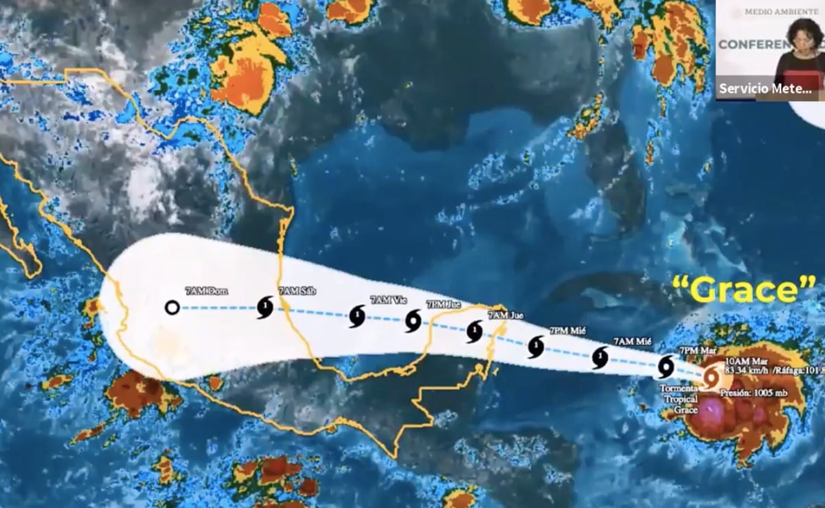
Cancun. – Fast movement of “Beauty” In Mexican territory will affect how Category 1 hurricane The vicinity of Tulum, in the north of Quintana Roo, will weaken into a tropical storm when entering Yucatan and will intensify again, affecting Veracruz, until Category 2 hurricane, according to National Water Commission (Kunagua).
This hydrometeorological phenomenon will also affect Tamaulipas, San Luis Potosi, Hidalgo, Guanajuato, Puebla and Tlaxcala, with heavy rains.
In Quintana Roo, the Green Alert – Low Risk – was issued today due to the approach of Tropical Storm Grace, which is expected to affect as a Category 1 hurricane in the Tulum area, starting tomorrow, according to the forecast.
The authorities called on residents to review the conditions of their homes, prepare an emergency bag with important documents, identify the nearest shelters and obtain information through official sources.
85 shelters are active in the state for the first time, 64 of which are in the northern region and 21 in the southern region.
The state’s governor, Carlos Joaquin, said the cities of Punta Herrero, Isla Maria Elena, Banco Chinchoro, Punta Allen and the Chunes region are also protected, as they are communities close to the area with greater vulnerability due to the influence of Grace. Gonzalez.
The second effect of “Grace” will be in Veracruz
coordinator National Weather Service (SMN), Today, Alejandra Mendez-Jerón reported that Grace was as of 10 a.m. this Tuesday, 1,095 kilometers east of Cancun, moving at speeds with winds of 85 kilometers per hour, with gusts of 100 kilometers per hour.
It is moving west at 24 kph and will continue its rapid movement across the Caribbean, making itself felt as of tomorrow afternoon in waves of 2 to 3 meters off the coast of Quintana Roo.
It is expected to escalate into a Category 1 hurricane tomorrow and make landfall between Wednesday night and Thursday morning in the northern part of the state, affecting Tulum, Playa del Carmen, Cozumel and Cancun.
By Thursday, it will be crossing the peninsula, affecting the Yucatan more intensely.
The official said that the winds will prevail between Wednesday night and Thursday morning, strong winds and strong waves.
On Thursday afternoon, August 19, Grace, due to its interaction with the Earth, is expected to weaken into a tropical storm and enter the warm waters of the Gulf of Mexico, where it is expected to intensify again as a hurricane.
In this way, it will impact on the night of Friday 20 or the early morning of August 21 across central and northern Veracruz, “as a Category 1 and even Category 2 hurricane,” with maximum sustained winds of 154 kph. , and back to the national territory, with heavy rain with the possibility of landslides and high waves on the southern coasts of Tamaulipas and Veracruz.
Grace will bring on-time torrential rain of 150 to 250 mm and winds of 120 km with gusts of 150 km per hour in Yucatan and Quintana Roo and waves of up to 5 metres.
In Campeche, timely and heavy rains of 75 to 150 mm and waves of 2 to 3 metres are expected.
During its second impact on Mexican territory, in Veracruz, it will cause 150 to 250 mm of rain in Veracruz, San Luis Potosi, Puebla and Hidalgo and from 75 to 150 mm in Tamaulipas, Queretaro, Guanajuato and Tlaxcala.
In addition to waves of 3 to 5 meters on the coasts of Veracruz and winds of 70 to 80 kilometers per hour in Tamaulipas, with accumulated rainfall of more than 250 mm in Yucatan and up to 400 in Veracruz.
Read also: The day the Sinaloa cartel stole the elections
afcl

“Bacon advocate. Certified creator. Twitteraholic. Tv junkie. Beer fanatic. Internet nerd. Passionate thinker. Reader.”


:quality(85)/cloudfront-us-east-1.images.arcpublishing.com/infobae/OF4NJDPGLBEYJAZ5XZMH3OIPJ4.jpg)


